
Innovating the net-zero supply chain:
leveraging data and integrated dashboards to drive sustainable logistics
SDG Goals:
SDG Goal 9: Industry, Innovation and Infrastructure
Build resilient infrastructure, promote inclusive and sustainable industrialization and foster innovation
SDG Goal 14: Life Below Water
Conserve and sustainably use the oceans, seas and marine resources for sustainable development
Topic:
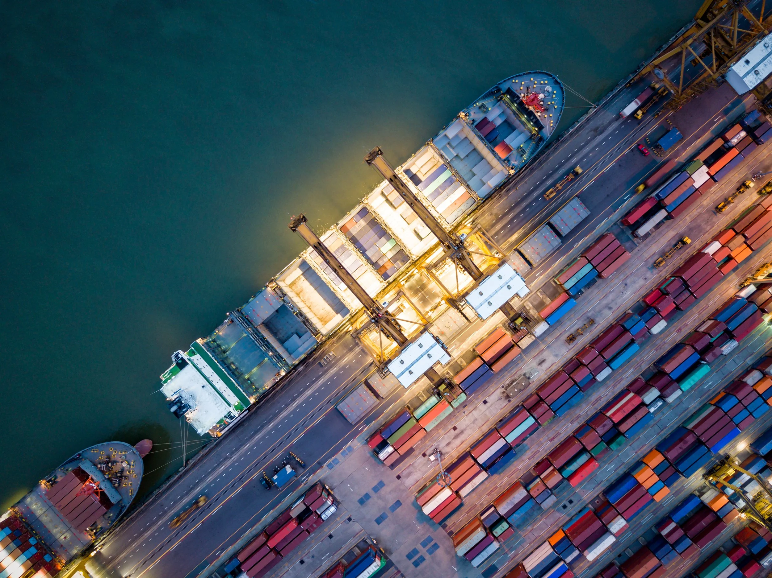
Achieving net-zero emissions in global supply chains requires coordinated decarbonization across maritime transport, port operations, trucking, and aviation. While deploying cleaner ships is essential, it is not sufficient on its own. Ports must modernize their energy infrastructure, invest in renewable sources, and enable low-carbon fuel adoption—advancing SDG 9: Industry, Innovation, and Infrastructure. Similarly, trucking and aviation, which connect ports to inland destinations, must accelerate the transition to zero-emission vehicles and logistics solutions. Coordinated action across these sectors can establish “green corridors” where goods move seamlessly and sustainably from origin to destination.
The maritime industry, responsible for transporting nearly 90% of global goods and contributing about 3% of global GHG emissions, is uniquely positioned to lead this transition. Its efforts go beyond reducing its own emissions; they set a precedent for the entire supply chain. At the same time, these actions must safeguard ocean health and biodiversity, aligning with SDG 14: Life Below Water, by minimizing pollution and promoting sustainable marine practices.
International cooperation is essential, as ships operate across global waters. Organizations like the International Maritime Organization (IMO) and industry leaders are advancing frameworks such as fuel-intensity standards and emissions-pricing mechanisms. These initiatives create ripple effects, encouraging ports, trucking, and aviation to align with net-zero ambitions while driving innovation and protecting marine ecosystems.
Satellite-derived Earth observation (EO) data offers a unique opportunity to provide consistent, spatially explicit, and independently verifiable indicators of transport activity and environmental impact on a global scale. However, the extent to which EO data can reliably measure decarbonization progress across multimodal logistics systems and consequently support credible green corridor implementation remains underexplored. This track explores how satellite-based atmospheric and activity proxies can be integrated with supply-chain data to monitor emissions trends, assess infrastructure transition, and support data-driven decision-making
Research Questions
How can Earth Observation and geospatial data (satellite data) be used to measure and monitor decarbonization progress across global logistics systems, including shipping routes, ports, trucking corridors, and air transport networks?
What innovative strategies can be integrated into a spatial supply-chain dashboard to support data-driven investment and infrastructure decisions that reduce emissions across logistics operations?
What benefits and challenges does integrating a spatial supply-chain dashboard to support data-driven investment and infrastructure decisions reduce emissions across logistics operations?
How can satellite-derived Earth observation data contribute to making green corridors operational, credible, and scalable?
How can satellite-derived environmental data reduce information fragmentation across transport modes and enable coordinated decision-making among stakeholders participating in green corridors?
Track Resources
Background Information:
Sustainable Development Goals | United Nations Development Programme
Green Logistics: The Future of Sustainable Supply Chains
Decarbonisation of Ports: Strategies and Technologies
How Other Sectors Will Fuel Maritime Decarbonization | BCG
SDG Action Segment Goal 14_0.pdf
IMO policy measures: What’s next for shipping’s fuel transition? | Global Maritime Forum
Track Resources:
Resources and data sources that are applicable and a helpful way to get started:
Offers methodologies for supplier-level emissions data collection, Scope 3 reduction strategies, and dashboarding for supplier performance.
A white paper detailing data governance practices, emission measurement challenges, and frameworks for supply chain co-reporting.
Covers the building of data analytics platforms to measure mode-specific emissions, ensure ISO-compliant tracking, and inform investment decisions.
Policy recommendations for electrification (cold ironing), renewable integration, microgrids, and grid modernization to support energy-based, sustainable ports.
Explores alternative fuel readiness—including natural gas, biofuels, methanol, e‑fuels—for hard-to-electrify sectors (aviation, shipping, heavy and inter-city trucks) and analyzes transition scenarios based on infrastructure, cost, and regulation.
An in-depth report analyzing collection, sorting, redistribution, incentives, and reverse supply chain infrastructure across circular logistics systems.
Empirical study showing how reverse logistics and remanufacturing significantly improve environmental, social, and economic performance in logistics firms.
Explains the principles of circular logistics and its role in minimizing waste and extending asset life through reverse flow management.
Explains how circular logistics—via route optimization, reusable packaging, IoT, and blockchain—extends product and asset lifespan across freight operations
Data Sources:
OECD Maritime transport CO2 emissions database: The OECD Maritime Transport CO₂ Emissions Database provides estimates of carbon dioxide emissions from global shipping activity, disaggregated by ship type, trade route, and country. How to access: Go to the dataset’s webpage on the OECD site; once there, click the “Access now” button. This will open or download the dataset as a CSV file, which you can import into Excel, R, Python, or any data-analysis tool.
The World Port Index (WPI) is a global database produced and maintained by Maritime Security Office of the US National Geospatial-Intelligence Agency (NGA). It provides standardized information on the location and basic characteristics of ports and maritime facilities worldwide. It includes port coordinates, harbor types, vessel and cargo handling capabilities, and available services. It offers a consistent reference layer for identifying and comparing ports along major trade routes. The WPI can be used to define green-corridor endpoints, link satellite-derived activity and emissions hotspots to specific ports and support integrated dashboards that combine port infrastructure characteristics with environmental and logistics data. You can view the application or directly download the csv data clicking on UpdatedPub150.csv on this page.
IMO Data Collection System reports: The IMO Data Collection System reports summarize fuel-oil consumption, distance traveled, hours underway, and estimated CO₂ emissions from all ships over 5,000 GT engaged in international voyages. While individual ship-level data is confidential, IMO publishes annual aggregated reports showing emissions trends across ship types, flags, and global regions. These reports are widely used for policy analysis and decarbonization research. How to access: download the public annual DCS reports directly from the IMO website. The reports are available as free PDF files and provide tables, charts, and summary statistics that can be manually extracted or imported into analysis tools.
Possible Satellite Data in Google Earth Engine
Sentinel-5P OFFL NO2: Offline Nitrogen Dioxide: This dataset provides global, high-resolution observations of tropospheric nitrogen dioxide (NO₂) derived from TROPOMI instrument aboard the Sentinel-5 Precursor satellite. The data is processed in offline (OFFL) mode for higher quality and completeness. NO₂ is a well-established atmospheric indicator of fossil-fuel combustion from transport and industrial activities, making it directly relevant for assessing emissions associated with shipping lanes, port operations, trucking corridors, and aviation hubs. Within this track, tropospheric NO₂ column can be used to identify and compare emissions hotspots along candidate green corridors, enabling evaluation of where logistics activity translates into significant air-quality impacts. When combined with activity indicators such as nighttime lights and corridor geometry, this dataset supports data-driven prioritization of decarbonization efforts and monitoring of progress toward net-zero objectives. NO₂ is widely used as a proxy for transport emissions, especially in urban areas. There is also real time data version of this.
VIIRS Stray-Light Corrected Nighttime Lights (NOAA/VIIRS/DNB/MONTHLY_V1/VCMSLCFG): This dataset provides monthly global composites of nighttime visible light intensity derived from VIIRS Day/Night Band. It is corrected for stray light to improve data quality, particularly in coastal and high-latitude regions. In context of green corridors, VIIRS nighttime lights can be used as a direct proxy for persistent logistics activity, including port operations, vessel anchorage areas, and heavily trafficked shipping routes. By masking urban land areas and focusing on water pixels, dataset enables identification and comparison of corridor-scale activity hotspots, supporting prioritization of routes and ports where decarbonization efforts are likely to have greatest impact.